Showing posts with label history. Show all posts

Sunday, January 22, 2017

Washington State Parks: South Cle Elum Railyard


Each step landed with a poof. A soft sound of gentle air lifting a fine dust of snow. Powdery snow floats and swirls around our ankles for seconds before coming to rest again; to mix with snow appearing undisturbed by our passing. The only sign we were there, a shallow trench dug by our snowshoes. We stop at each sign on the history trail, imagining a world long ago past and what historical treasures might be hidden beneath the snow.

South Cle Elum Railyard is an affiliated state park narrating the story of the once great Milwaukee Railroad. In the early 1900’s, the Milwaukee Railroad decided to expand into the northwest to compete with two other transcontinental railroads that were already established in the area – the Northern Pacific Railroad and the Great Northern Railway. Division points where locomotives were serviced, crews switched, and passenger embarked and dis-embarked were located 100-150 miles apart. South Cle Elum became one of these division points. The Milwaukee Road ceased its operations in Washington during the 1980’s and transferred ownership of the rail station to the state to “pay” its tax debt. In 2003, the rail yard and buildings were listed on the National Register of Historical Places.

A short trail loops through an eastern Washington meadow. Look for wildflowers and small birds as you pass from one interpretive sign to the next. Remnants of the rail yard still exist in the meadow and can add interesting details to your images. The old rail station houses a BBQ restaurant and museum but still has its early 20th century charm with multi-paned windows and wide wooden platforms with benches to sit upon and watch the afternoon drift away.

Getting There: From Snoqualmie Pass follow I-90 east to exit 84 (Cle Elum/S Cle Elum). Continue on 1st Street to S Cle Elum Way, turn right. Turn right on Madison Ave then left on 6th Street. Turn right on Milwaukee to the parking lot. From Ellensburg follow 1-90 west to exit 84 (Cle Elum). Continue on Oakes Ave to 1st Street, turn left. Turn left onto S Cle Elum way and follow directions above.


Monday, July 15, 2013

Cataldo Mission


On a hill overlooking the Coeur d'Alene River and valley sits the oldest building still in use in Idaho. A mission built by the Coeur d'Alene Indians after they journeyed east to find medicine men in black robes and carrying spiritual books. And the black robes, Jesuits, came. Originally it was built along the St Joe River, but the area was prone to flooding, so the Jesuits found a new home for what was named the Mission of the Sacred Heart. The mission became a place of worship and learning for the Coeur d'Alenes and later a wayside for miners and settlers.

The mission is now an Idaho state park and is listed on the National Register of Historic Places.

I had the opportunity to visit the mission on a recent road trip to Montana. I had been driving past the park for several years and thought "I should stop in and see what this is all about." But I always felt too rushed to stop, which is silly since I like to take road trips so I don't feel rushed and can stop by little wayside gems like these.

This trip though, as I drove past to get to my destination in Montana, I told myself that on the way home I will stop. And so I did.

After watching the informative video and meandering through their exhibits, I made my way in the mid-day heat to the mission and parish house on the hill. It took the Coeur d'Alene 3 years to build the mission with the materials they had on hand - not a single nail was used in the construction. The chandeliers were made from tin cans and the wallpaper was either cloth from the Hudsons Bay Company or newspapers with painted designs in blue. The blue paint was actually stain made from crushed huckleberries.

You could almost feel the love in the craftsmanship of the Coeur d'Alene - the hand hewn flooring, the cut tin, the carvings on the alter. I laid on my back admiring the colors of the ceiling, the large center panels stained in huckleberry juice. Such care for an adopted religion that, for better or worse, brought education and civilization to the frontier and beyond.

The mission and parish house are simple buildings built on on a hill that was at one time beyond the edge of civilization. Now an interstate runs past it leading cars and people to other places at high speeds.

So while on your next trip, why don't you slow down for an hour or two and visit a quiet wayside for history or nature or for peace.

Tuesday, July 02, 2013

Visions from a Race


Each year I head to Lolo Pass on the Idaho/Montana broder to photograph the Mountains to Meadow Half Marathon and 5k Fun Run. It's a fun event that I look forward to every year - beautiful location, fun people, and a chance to get away to do what I love for a good cause.

From the start, I saw this event as unique and spirited, celebrating the history of the area.

You see, Lolo Pass is where Lewis & Clark crossed the Bitteroot Mountains. Graves Creek meanders through the Camas fields near the pass and the adventurers camped on it's banks for a time. They were surprised by the Camas and described the flower and it's nourishing roots in their journals.

As part of the race, Corps of Discovery re-enactors come to the race to demonstrate history and to fire the pistol at the start of the race. Well, actually what they fire is a flint-lock rifle. Always a fun start.

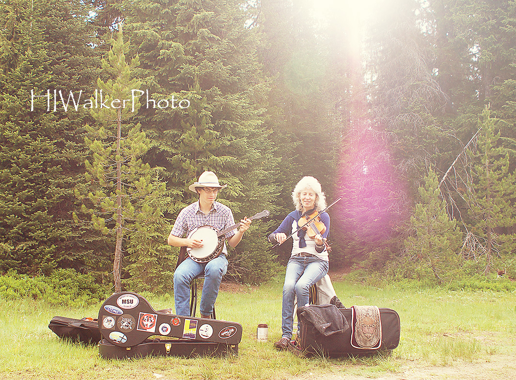
This year to add a little more flair to the event, celebrating the 207th anniversary of Lewis & Clark crossing Lolo Pass on June 29th, the organizers brought in a Bluegrass Duo to serenade the runners as they came past.

The runners were at first surprised, others joyful as they trotted past. Our musicians completely tickled by the event.

They promised to come back.

Monday, March 01, 2010

There be Ghost Towns here!


Melmont & Manly Moore, 2/28/10, 10 miles, 100 elevation

Tucked away in the dense rainforest northwest of Mt Rainier hides a pice of Washington history un-noticed by the outdoor enthusiasts rushing to the many trails and camp sites closer to and inside the park. A history reflected in the names given to features and settlements in the area: Carbon River, Carbon Glacier, Carbonado. A history that supplied the nation with fuel at the turn of the 20th century. A history of a vibrant life, ending so suddenly remnants are still seen if one knows where to look and takes the time to slow down for a glance.

The towns of Melmont, Fairfax, and Manly Moore were once thriving coal mine towns serviced by a railroad and train arriving once a week. After more pure coal was found and mined elsewhere in the country, the town structures were dismantled and the railroad tracks pulled up. But even now, a walk along the old railroad bed will turn up treasures telling of a history not long in our past yet almost forgotten.

The foundation of the old Melmont schoolhouse still overlooks the level meadows where the town once resided. An old work trucks rests in the embrace of a vine maple where it was abandoned so long ago - moss and fern replacing the paint and hinges. A shack still stands along the trail and stories tell of explosives being kept there. And here and there along the way evidence of a once rich coal mining area spills from the hillsides.


Monday, October 19, 2009

Chaco Canyon


10/7/09

Dark and lonely rural road late at night. No one else around as we drove along, static playing intermittently on the radio scanning for a station - any station. "Make a right up here." We turned just as another set of headlights appeared coming toward us. They turned to follow. They appeared to be catching up. I didn't say a word, but I knew what Michael was thinking. He had watched one too many horror movies. As the car following gained on us, Michael pushed the gas pedal closer to the floor. And he wonders why I don't watch those types of movies. "Our turn is coming up." I hoped the car wouldn't make this turn also - Michael's paranoia was rubbing off on me. We turned, the other car continued on. whew. But that would not be the last of our concerns. The last 20 miles to Chaco Canyon were on a heavily potholed and washboarded dirt road. If we broke an axle out here . . . I don't want to think about what would have happened. Sure, someone would have come along at some point.

As the next day dawned, we were rewarded with Chaco Canyon and its wondrous ruins. I saw my first pueblo ruins while in New Mexico several years ago and was enraptured by the story and the fantasy of it all. Walking through the ruins of the Chaco Culture only emboldened the images in my mind. Here was a valley filled with communities large and small of lives lived centuries ago.

There are 6 pueblos along the road through Chaco Canyon all within easy walking distance of each other. We meandered from one to the other, stopping to observe petroglyphs on the sandstone cliffs or watch the Cliff Sparrows flit in and out of their nests. We had a wonderful morning speculating what the drawings meant or how the ancient people lived. All the while we wondered when we could come back to explore the 6 backcountry ruins.

We both became fascinated with the different construction methods - how the bricks were laid, the wood supports. Including how these structures have been able to stand over the elements and the years. Time and weather have taken their toll and we watched as park employees worked on shoring up the crumbling walls. It may be race against inevitability,but while the structures last, we have a small window to view a past in all our lives.


Sunset Crater


10/5/09

Every now and then we stumble across a hidden gem while on a road trip. This trip we stumbled across two gems in the National Park Service that we never heard about. The first is Sunset Crater, a volcano that erupted centuries ago and disrupted the lives of the native peoples who lived in the area. The story of Sunset Crater still lives on in the narratives of local Indians.

Our stay would be overnight and it would be our coldest night on the road. We had a fabulous fire to warm ourselves before going to bed. I had hoped to stay up for star trails, but the temperatures were dipping into the low twenties. The fire and my sleeping bag sounded far more comforting that a chilly night beside the tripod.

In the morning, Michael & I explored the nature trail behind the volcano. We would have liked to make the climb, but the park service closed down climbing on the cinder hill when the trails created gaping scars in the slope. Thirty years later we could still see the scars in the hill.

It's a great little place to see and highly recommended a stop.


Sunday, October 18, 2009

Grand Canyon


10/4-10/5/09
My hands rested lightly on the rail. In front of me a hole deep and wide filled with the colors of the ages. I was here. On the edge. The most famous hole in the world. A gash so wide, so long it takes days to travel the rim or to float down the Colorado River that tirelessly carved this masterpiece that we know as the Grand Canyon. I couldn't stop the smile from my lips or the satisfaction in my heart.

I wanted to drink in the scene in front of me - the color, the lines, the light. The mesas and ridges faded off into the distance as the sun faded in the sky. This was a moment of discovery and I wanted it to last. And I wanted to share it. The light finally faded from the sky and we made our way to find camp - to set up the tent in the dark and make a dinner I was glad we couldn't really see. At least it went down all right.

Predawn and I found myself walking along the road to the lookout closed to all vehicles except the shuttle which hadn't started its run. I was there alone. Surely there must be someone else here in the early morning cold and wind. No one. I wandered along the rim to see where I wanted to be as the sun rose above the horizon. It was the alpenglow on the mesas that stopped me in my tracks. They seemed to vibrate with color and light. I alone was its witness. A discovery for myself, a discovery to share.


Later, after a visit to the Kolb Studio, we rode the shuttle to Hermit's rest for a hike back. Glimpses of the river below made us yearn for a trip of a lifetime. What I would give for that trip. To see the canyon from such a view. To explore the side canyons. To explore the ages.

We took a side trail, the trail that was replaced by the new wider and paved trail that was farther from the rim. We wanted to be closer, to see over the edge. An amazing experience to see down into the canyon while hanging onto a tree clinging to the edge - your only support from falling in. Then below us a fox darted along the edge. Something we would never had seen if we had stayed on the paved trail. He darted into a crevasse then back out and around the corner. Now that was a great little experience.

As we soaked in the day's experience over lunch, a large dark shaped floated on the winds just above the canyon rim. A condor. How great! Condors drifting on the canyon's currents. I about jumped out of my seat to run for that shot. We saw them after lunch basking in the warmth of the sun, wings outstretched just below us. I was ready to stay longer, but our whirlwind trip spurred us on.


Monday, April 06, 2009

1st stop - The Palouse


3/29/09

The forecast called for snow again over the weekend proving that spring was still far away, yet the vibrant colors in the flower stalls in the market prior to my departure rallied my hopes that spring would indeed be right around the corner. Furthering my hopes that spring would be quickly on its way, the drive over the pass to Spokane revealed more land as the snows receded, the ice in the waterfalls replaced by flowing water. Yet this morning we woke to snow falling on the hills of the Palouse - winter was refusing to release its hold on the northwest.

However, I had been looking for this up close look at the Palouse by people who lived in the area, I was not going to let it pass. We did pass planned photo-op after photo-op as the falling snow made distant views non-existent. At breakfast we were joined by a local farmer turned historian, Glen Leitz, who shared with us bits and pieces of the history of the Palouse. I always enjoy listening to oral history and this gentleman had a lot to tell, so much in fact that we had to leave before he even finished his stories.

We continued on our journey as the snows started slacking off so we were able to stop at more places - museums, barns, mills, churches and cemeteries. All unique in their photographic qualities. I began to realize I would need to come back for several days to truly capture this rare and beautiful place. Finally, the clouds started breaking apart in the late afternoon and the sun highlighted the hills in the distance. Just in time too, our final stop near sunset would be Steptoe Butte.

Never seeing Steptoe before, I was extremely excited as I drove up the winding road to the top. Each turn revealed more of the scenery - rolling hills touched with snow stretching in every direction. I decided to leave before sunset - eager to be on my way and hoping to be someplace really cool for sunset. I was in a gully at the best color, but a not too disappointed because I knew my trip had started off great - even if spring was reticent in its appearance.


Tuesday, March 10, 2009

Scouting Trip


Ebey's Landing, 3/1/09, 4 miles, 250 elevation

On a blustery type of a day, Michael & I went to scout a trail we'd be leading a hike on later in the month - Ebey's Landing. I had often read about this little trail and the bounty of flowers in the spring. March is a little early for flowers, but we scheduled the trip anyway to accommodate our Mountaineers Hike Mentor. To become hike leaders for the Mountaineers, we had to lead a hike under the supervision of a certified hike leader.

We packed extra layers expecting a bone-chilling wind and made sure the dogs had their coats, but those were not needed. e were peeling off layers barely a mile into the hike. The sun even glowed brightly behind a thin veil of clouds. The wind never materialized - amazing as we hiked along a high bluff over-looking the Strait of Juan de Fuca and Admiralty Inlet.

The hike itself is a leisurely paced trail along the bluff and completes a loop along the beach. Even though flowers were not yet blooming, we saw quite a bit of wildlife including a sea lion swimming through the kelp just off the shore.

And now that we have scouted the trip, we feel comfortable enough to lead the hike later on.

Tuesday, April 08, 2008

The Soggy Mess of Me


Fort Columbia, Spring Road Trip, 3/23/08

The rain was falling steadily as I broke camp at Cape Disappointment. I have many fond childhood memories of the Willapa Peninsula and the little town of Oysterville on the tip. Grandma lived in Oysterville and her grandchildren spent many a summer day running and laughing on the beaches that surround it. Every time I visit the area, I need to stop by Oysterville just to say hello to the familiar structures. The rain appeared to pelt the windshield as I pulled up next to the fence around the community center, but I still had to jump out for a few shots before heading out of town and toward the Columbia Gorge.

Just east of the Astoria Bridge stands the Fort Columbia State Park. As I had never explored the park and the rain had let up a bit, a stop seemed warranted. A walk down the hill to the battlements was a bit muddy and rain puddles the hallway through the cement structure. Quiet solitude greeted Olympia and I as our steps echoed off the cold grey walls. But the vision I saw looking down the hallway was spellbinding.

The door at the far end of the darkened hall was set in an eerie green-white wall reflected in the puddle on the floor. It was magnificent but I needed my tripod which I had left in my car. I hurriedly walked back to the car and on my return back down the hill . . . well one misstep tells it all. I was covered in mud. Mud oozed into my shoes. Mud dripped from my jeans. Mud caked into the creases of my hands. I tried my best to at least wipe off my hands on a clean spot on my sweater before continuing down to the battlements. I had to get that shot.

You tell me, if it was worth it . . . .


Wednesday, May 09, 2007

A Story to Tell


Trail of Shadows 5/5/07 .7 miles


After touring the damage on Mt Rainier, Michael & I walked around the Trail of Shadows near Longmire. The Trail of Shadows is a short nature trail that encircles the mineral springs which brought James Longmire and his family to settle in the area.


After leading a group of climbers to the mountain, Longmire went in search of his horse which had wandered off during the days of climbing, as horses will do. He found the horse grazing near the mineral springs, a feature of the area that had up until now been hidden from history's gaze. He later brought his family to homestead in the area with dreams of opening a resort. Mineral baths were all the rage in the latter half of the 19th century.


Now all that remain of Longmire's original dream are a few bathing areas and an old cottage. But the dream is still alive in the remembrances of the dreamer. Michael & I meandered through the old growth forest past the cabin and the baths. We gazed out over the meadow and watched as the discolored water bubbled to the surface. And at each sign we stopped to read what story there was to tell.


It's that way with all nature trails. Take time to stop along the way and meander along a short trail; read the signs. The history you learn keeps the dreamer in all of us alive for it is in the telling that a story breathes life.