Showing posts with label Mountains. Show all posts

Tuesday, August 18, 2009

Birthday Wishes

Camp Muir, 8/15-8/16/09, 5 miles, 4500 elevation

A few years ago on her birthday my sister jumped out of a plane. It had been a dream of hers for several years and she finally made plans for her birthday. I sat and watched her as she slowly floated through the sky, landing safely with a smile extending ear to ear, inspiring me to pursue my own birthday dream - sleeping overnight at Camp Muir. So I made my reservations for the weekend and watched with growing horror as the weather warmed, snow melted, and crevasses became exposed in the snow field below Muir. I have no experience in crevasse travel and wasn't sure I wanted my special birthday trip to be my first experience. The ranger at the climbing desk reassured us that as long as we had ice axes, crampons and the knowledge to use them then we were prepared well enough. Slight assurance, but I was with Michael & David and knew that they would not push our luck.

Michael had been suffering from an illness all summer, so had not been able to go hiking with me much. nor had he been able to train in other ways. As we climbed up through the clouds getting closer to clear skies, Michael fell further and further behind. My concern for him began to mount as I eyed our route up the mountain. I decided that I would head back if that was what he wanted. Barring eruption, Mt Rainier would be there another year.

We stopped for lunch at Pebble Creek, our halfway point in mileage. Michael broke the news to us; he would have to turn back. But he would hear nothing of Dave & I turning back with him. I looked up the mountain. How was I supposed to make it without him? The route, the fear, the experience - I needed Michael to b there to help get me through it. We traded equipment and supplies - he took anything I would not need and made sure I had the lighter equipment. With a tear in my eye, I followed Dave up the hill as Michael waved to us from the creek.

It took us 4 hours to climb the last 2 miles. Climbing on snow is not bad, rather easy compared to climbing over rocks. It was the elevation gain that slowed us down. And then we got to the ice. At first I thought we were walking on marble, but then I realized that it was ice embedded with gravel. An interesting phenomenon that kept my mind occupied as I stepped over one crack and the another. Finally I stopped as I realized I was walking over crevasses. My heart skipped a beat. I watched as Dave kept climbing. I sucked in a breathe or two . . . or three before willing my feet t continue. Geez! Once I get up there would I have the courage to go back down? The largest crevasse still lay ahead of us - several feet wide, an over-used snowbridge spanning the gulf. Was that a foot hole where someone passed through? My first response was "Oh Hell No!" But Dave coaxed me across as soon we were stumbling into Camp Muir.

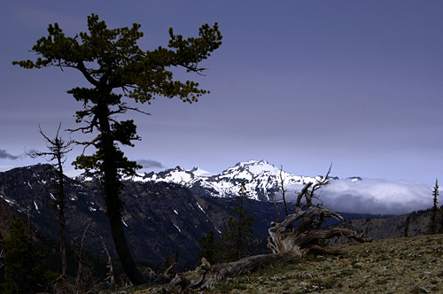
We set about quickly building camp; Dave digging the tent platform and I started melting water for dinner and to refill our bottles. All the while I sat amazed - I was at Camp Muir. I made it. And look at that view! Clouds covered the valleys to the south, but eastward the mountains peaked through. The temperature dropped as quickly as the sun lowered below the horizon. We took refuge in the tent and I warmed up, but for some reason couldn't stop shivering. That and the cold would keep me up most the night. I stepped out of the tent at one point to a sky filled with stars; the Milky Way seemed close enough to touch. A few climbing parties were already making their way up the mountain - their headlamps bobbing in the darkness.


The next morning, I roamed through camp - a community of people laughing and sharing stories. There was a great sense of camaraderie and I found myself accepted as one of their own. Even as I told them that I had only come to spend the night at the camp, they welcomed me warmly and shared some of their favorite climbs.

As the morning warmed, Dave & I strapped on our crampons next to a pair of ladies also preparing to head back down. Like us, they had only spent the night in Muir. They were planning on roping up - one of the gals had fallen through the crevasse, the one with the foot hole. Even though I was nervous, I was going to trust that I would make it down the mountain safely. Sure enough, without incident we were through the crevasses, down the snowfield and walking through the alpine meadows of Paradise. Michael was waiting for us at the Visitor Center with open arms and bottles of water. As proud as I was at fulfilling my birthday wish.


Tuesday, June 09, 2009

A Guidebook Complaint?


Pete Lake, 6/7/09, 9 miles, 400 elevation

When I read a guidebook, I expect just a few things. Accuracy in mileage and elevation; a detailed description are basically what I want. Over the years I have been able to decipher the author and that they may be leaving out information. If an author glosses over a section of a trail then they either don't want to tell you something or they have never been there. I often wonder about this last. I know that with the older books by Ira Spring, he leaves out details because he didn't find them necessary - other things were important. But a few of the newer authors I'm wondering if they are leaving information out because they are writing the trail description from a map.

Take a recent hike to Pete Lake in Eastern Washington. The author of the guidebook tells you of all the animals you could see while hiking, but never really talks about the trail. The hiker will pass a swampy area (that can be seen on a map) and hike through trees (no duh, since we are in the mountains of Washington then you come out into a mountain bowl with a lake (well since we are in the mountains hiking to a lake I would think so.

What was left out were the 6 major stream crossings without bridges. Were there bridges and they washed away? Just mentioning bridges and stream crossings would tell us. The forest here does have a habit of taking out bridges on some stream crossings so they won't be washed away - if they do that wouldn't it be a good idea to mention that in the guidebook? To me a guidebook is there to give you as much necessary information to stay found and unhurt. leaving information out does the hiking community a dis-service.

Oh, and the hike to Pete Lake? A lovely stretch of the legs through the woods along a river. And you should go if you get the chance.

Monday, July 07, 2008

Can't I Stay Here, Forever?


Esmerelda Basin, 7/6/08, 7 miles,

The valley stretched out before me, green tones for miles, ending with the still snowy mountain rising up from the forest green to balance together the earth and sky. Somewhere behind me, Michael was curled up in the shade of a few alpine-sparse trees taking a nap on this perfect day. Zillah trotted around the pass searching out new and different smells looking up every now and then to make sure I haven't left her.

Here would be our turn-around point - Fortune Cookie Pass - but I had no desire to return. The valley and mountains beyond called to me. The barely-visible trail leading up to the peak through the snow banks whispered my name and promises of an even more enticing view from above. Yet even those calls to my inner thoughts couldn't move me. At the pass I was happy, standing in the sun and wind. This view was the view I had been hoping for all summer and the snows had kept me from for so long. It was a view of open air where a person could see for miles without obstruction from a vantage point that is tundra-like in its sparseness of vegetation. And my soul had ached for it throughout the wintry June on the wet-side.

As Michael rumbled awake, stretching out the kinks and knots, I hoped he would want to sit for the afternoon on the fallen tree overlooking the valley. Zillah bounded up to him as he sat next to me and commented on the chill wind. I paid the wind no mind; I called Michael a wimp. But I knew it was time to leave. To head back down the talus field to the flower-filled meadows below, past the waterfalls and pine trees, to the car waiting below to take us home again.

But couldn't I just stay here?


Well Worth a Sprinkle, or Two


De Rouex Creek, 7/5/08, 8.2 miles,

4th of July weekend and wee had 3 days to play, but with snow still hanging out in all of primary choices on the westside of the mountains we decided that heading east would be the better of the bargain. There are a couple of trails in the Teanaway we wanted to explore and with a base camp somewhere along the river, we could easily head to each.

First on the list was DeRouex Creek. I had been up this trail previously with the Mountaineer's Naturalist Class and wanted to head further into the mountains than the naturalists had gotten. With spotty clouds overhead Michael, Zillah and I crossed the North Fork of the Teanaway and started out on the day's adventure. Almost immediately the wildflowers lined the trail - Lomatium, Jeffrey's Shooting Star, Red Columbine, Vanilla Leaf and Violets.

As we climbed higher, we came across Penstemon, Arnica, Liuna, and Asters in greaterr abundance. And then the trees opened up to meadow with more Shooting Stars and our first Avalanche Lilies, but the clouds that had been building throughout the morning started to let loose in spurts. We were prepared and threw on our rain coats before continuing on up to Gallagher Head Lake. Along the way we saw more Columbine, Arnica, Shooting Stars, Lupine and Avalanche Lilies.

There were only a few people at the lake when we reached its shores and clouds obscured the peaks enough that all we got were teasing glimpses of what stood beyond. However, there is an old jeep road leading up to the lake and some 4-wheelers had played too often and too close to the shore and deep ruts had been created and left for the rest of the world to look upon in disgust.